Wet - but a month of two halves
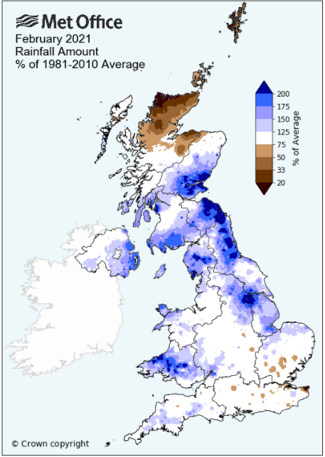
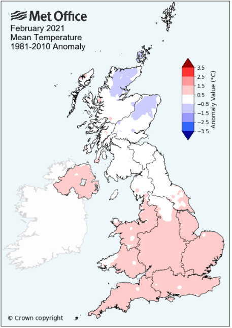
February could almost be described as a month of two halves, a cold and wintry first half followed by a mild, wet, unsettled second half with the final outcome being yet another very wet February, but one which was virtually average for temperature.
In that colder first half the month started cold with snow falling on the 2nd that caused a small amount of disruption and then after a quieter interlude 3rd - 6th, it again became cold and wintry with further light outbreaks of snow, but with some particularly cold nights which saw both Maulds Meaburn and Shap (-11.6°c) record their lowest February minima.
Then from the 14th a succession of low pressure systems arrived from off the Atlantic bringing much milder conditions, but also some very heavy daily falls of rain; parts of the LDNP having two separate days with falls that exceeded 100mm. By the 25th, when high pressure became dominant, the ground was truly saturated and rainfalls totals had risen to well above average.
Some consolation came with the final four days of the month which were settled, dry and actually quite sunny.
MSLP of 1012.9 Mb was -1.0 MB below the local average for the month and overall a mean minimum of 0.70°c and a mean maximum of 6.48°c saw the temperature 0.15°c below the twelve year average for this site.
It was the coldest since 2018 and of the thirteen now recorded, six have been warmer and six have been colder - the highest maximum temperature recorded being 11.5°c (20th), the lowest minimum -9.0°c (11th).
Rainfall of 185.1 mm (Maulds Meaburn North 177.8 mm -- Castlehowe Scar 275.8 mm) was 171.1% of average for 2008-20 and made it the driest February since 2019. Of the fourteen now recorded, two have been wetter and nine have been drier.
During the month the following was recorded: snow fell on 5 days (2nd, 7-10th), 4 days of 'Lying Snow' (2nd, 9-11th) and fog on 2 days (2nd, 5th). The wind speed averaged 7.75 mph, with a maximum gust of 48 mph (19th).
At the Met' Office site at Newton Rigg a mean temperature of 3.78°c is 0.2°c warmer than average and is the coldest since 2018. In a series back to 1952 (1 year with no data), 39 have been colder and 29 have been warmer.
Rainfall totalled 106.8 mm (143.7% of average), making it the driest since 2019. Since the record began in 1900, 23 have been wetter and 97 have been drier (1 year with no data).
At Appleby in Westmorland a total of 119.3 mm represented 176.7% of its average (1857-2020) and made it the driest since 2019 - in a record that commenced in 1857, 18 have been wetter and 146 drier.
Rainfall totals across Cumbria were well above average and in most cases above 150% of average. With 143.7% of its average, Newton Rigg had one of the lowest percentage totals, yet relatively nearby at Brothers Water it was as high as 205.3%.
Figures from the Environment Agency�s rainfall sites were, (figure in brackets being the monthly average for 1961-90) �Data kindly provided by the Hydrometry and Telemetry team of the Environment Agency (Penrith)�:
Kirkby Thore 81.0 mm (48.7 mm)
Haresceugh Castle (Kirkoswald) 90.98 mm (56.6 mm)
Brothers Water 394.15 mm (192 mm)
Orton (Shallowford) 234.0 mm (139.3 mm [average for 1967-2019])
474.6 mm at Seathwaite Farm (Borrowdale - 272 mm [average for 1981-2010]) - making it the driest since 2019 and in a record that commenced in 1845, 149 have been drier and 27 wetter.
.
General Synoptic Report for the Month
A slack pressure gradient at the start of the month saw a cloudy but bright day 1st and with overnight frosts 1st and 2nd. Cold air lay to the north of the UK with warmer air to the south and overnight into the 2nd these met above Cumbria and brought a spell of snow that resulted in a cover that was 6cm deep come the 09h Obs. Snow fell through into the afternoon before the warmer air pushed further north which saw that snow turn to rain and which would now stay throughout the rest of the 2nd and most of the 3rd.
Whilst the fronts on the 2nd/3rd had brought 14.8 mm and 12.2 mm of rain/snow respectively and in spite of fronts remaining over the UK for the next few days, daily totals were now no more than 2.4 mm. The 4-6th saw overcast conditions with the occasional spell of rain and with day-time temperatures rising to a seasonal average of just over 6°c.
Those fronts just sat over the UK for the period before finally clearing south during the 6/7th and with high pressure (HP) between Greenland and Norway (latterly Norway and ridging down) a brisk E'ly flow was introduced resulting in a cold and wintry spell of weather. Shap would see its record lowest February temperature beaten twice in a matter of days (Shap has a 27yr record) and here at Maulds Meaburn my new lowest February temperature was also recorded.
It really did feel raw in what was a brisk wind and the 7th saw a month's lowest maximum of just 0.3°c and showers of graupel (soft hail) during the day. More sunny intervals and showers of graupel on the 8th, but a hours worth of snow at tea-time would give a lasting cover 2cms deep and now through to the 13th the night-time frosts would become severe. Clear skies overnight into the 9th saw the temperature fall away to -6.1°c (Shap -11.2°c), the day starting with that 2cm cover of snow. The 9th and the next few days would also see some decent amounts of sunshine and the odd wintry shower, but it was cold with day-time maxima initially 1-2°c although rising from the 11th.
The 10th was similarly cold, but again those clear skies and the snow cover saw the temperature fall to -9.0°c (15.8°f) overnight into the 11th (Shap -11.6°c). Whilst the next two nights were nowhere near as cold, the frosts were still sharp, but the compensation was fine, sunny days. The small amount of snow that had fallen at the start of the period would be enough to see three 'Days of lying snow' recorded, although come the 11th it was a case of only just. The 13th would be the final day of the cold spell and it was bitter cold with the temperature remaining below freezing all day and well into the evening - The HP over Norway had been holding a LP system out in the Atlantic at bay, but now the LP would win out.
Fronts associated to that LP arrived late on the 13th and overnight into the 14th the temperature would slowly rise. And with those fronts came rain - from 0930h through the rest of the day to give 16.2 mm.
The cold spell was certainly over and now the month would turn unsettled, mild and increasingly wet.
A succession of LP systems arriving from off The Atlantic brought those unsettled conditions, although in between these systems there were brief glimpses of the sun, 21st/22nd. Rain or drizzle fell on each day of the period through to the 24th and the 17-20th and 23rd/24th were also windy. Rainfall totals during the 15-18th were typically 5-8 mm, but with a deep (955 MB) and slow moving LP system pushing numerous fronts across the UK on the 19th we saw 25.1 mm followed by 17.9 mm on the 20th as a new area of LP quickly developed SW of Eire and rapidly moved north across the UK.
The 19th was particularly wet over the LDNP with falls of 110.2 mm at Seathwaite and 85.94 mm at Brothers Water.
After the improvement of the 21st/22nd, but which still saw some rain overnight, which saw a very brief and weak ridge of HP nudge in on the 22nd, the 23rd would be terrible and easily the month's wettest day. Another deep and slow moving LP system would park itself out to the west of Eire and its associated frontal system became semi-stationery over the western portion of the UK. Here at Maulds Meaburn the rain began to fall just after midday and by 1500 hrs was falling heavily, continuing throughout the evening and then overnight into the 24th although now easing, but still providing a final total of 52.0mm for the 23rd.
Other 24hr falls recorded on the 23rd included: Brothers Water 117.2 mm -- Seathwaite 111.0 mm (making a second fall in the month that exceeded 100mm) -- Orton 61.8 mm -- Kirkby Thore 19.2 mm
The 24th saw a damp drizzly day, although with more organised bands of rain in the afternoon, before clearing during the evening - at least now the rain was done and now HP would build from the SW, becoming dominant over the UK, building to a high of 1041.7 MB on the 27th here at Maulds Meaburn to provide for a quite satisfactory final four days of the month.
With the ground truly saturated most importantly it was dry. It became cooler at night, although no air frost was recorded and day-time temperatures responded to any sunshine and whilst not excessively high, were pleasant enough, the last two days just creeping above 10°c - but at least there had been plenty of sunshine.
WINTER 2020-21
The rarity of a colder than average winter and one which actually had a slight wintry flavour about it!
December was a mixed and unsettled month, cool and wintry at times, then mild at times, but with rainfall a constant companion. January was the 'wintry month' of the season, much cooler than average, snow fell throughout the month, particularly during the first half when there was a good number of 'Days of lying snow' (six at Maulds Meaburn) and whilst it was slightly drier than average, it was still wet at times.
February was the month of two halves, a first half of a cool and slightly wintry nature, followed by a wet and mild second half, although the final four days were fine and sunny.
Here at Maulds Meaburn this saw most of the 'wintry indicators' being above average during winter, notably: air frost (+8.5 days above average) -- ground frost (+6.0) -- Snow falling (+6.7) -- Day of lying snow (+1.4)
Here at Maulds Meaburn rainfall totalled 486.9 mm (Maulds Meaburn North 469.0 mm). This makes it the fourth wettest (of 14) in my records and is 118% of the average rainfall for those previous thirteen winters.
A mean temperature of 2.80°c is the coldest since 2010-11 and the third coldest of the twelve now recorded. It was 0.89°c colder than the average of those previous eleven winters.
At Newton Rigg rainfall totalled 391.2 mm and had a mean temperature of 3.10°c. In comparison to the 1981-2010 averages this represents 139.6% of winter rainfall and is 0.3°c colder than average.
This makes the winter of 2020-21 the twelfth wettest in a series back to 1900-01 (3 yrs of missing data) and in a series back to 1953-54, 29 have been colder and 38 warmer. In the much longer series back to 1914-15, but with 8 missing years, 57 have been warmer and 40 colder.
At Appleby In Westmorland 365.3 mm (141.9%) it was the 19th wettest of 165 years and at Seathwaite (1322.0 mm - 125.6%) it was the 43rd wettest of 177.
At the Met' Office site at Shap the final figures for the winter (along with the departure from average) for the winter were: mean temperature of 2.2°c (-1.1°c) -- Air frosts 43 (+1.6) -- rainfall 685.0 mm (111.9%)
Rainfall totalled 185.1 mm for the month, with rain recorded on 20 days of which 17 were 'Wet days' (1.0mm +).
The Mean Temperature for the month was 3.59°c -- The Mean Max' was 6.48°c -- The Mean Min' 0.70°c.
We had 9 Air Frosts in the month (year 29) -- Grass Frosts totalled 15 (year 39).
The 1 foot soil temp ranged from a low of 1.5°c on the 14-15th to a high of 6.8°c on the 25th -- with a monthly mean of 3.8°c
The 1 meter soil temp ranged from a low of 4.4°c on the 16th to a high of 6.1°c on the 26-28th -- with a monthly mean of 5.1°c
JANUARY 2010
FEBRUARY 2010
MARCH 2010
APRIL 2010
MAY 2010
JUNE 2010
JULY 2010
AUGUST 2010
SEPTEMBER 2010
OCTOBER 2010
NOVEMBER 2010
DECEMBER 2010
JANUARY 2011
FEBRUARY 2011
MARCH 2011
APRIL 2011
MAY 2011
JUNE 2011
JULY 2011
AUGUST 2011
SEPTEMBER 2011
OCTOBER 2011
NOVEMBER 2011
DECEMBER 2011
JANUARY 2012
FEBRUARY 2012
MARCH 2012
APRIL 2012
MAY 2012
JUNE 2012
JULY 2012
AUGUST 2012
SEPTEMBER 2012
OCTOBER 2012
NOVEMBER 2012
DECEMBER 2012
SUMMER 2012
REVIEW OF 2012
JANUARY 2013
FEBRUARY 2013
MARCH 2013
APRIL 2013
MAY 2013
JUNE 2013
JULY 2013
AUGUST 2013
SEPTEMBER 2013
OCTOBER 2013
NOVEMBER 2013
DECEMBER 2013
REVIEW OF 2013
JANUARY 2014
FEBRUARY 2014
MARCH 2014
APRIL 2014
MAY 2014
JUNE 2014
JULY 2014
AUGUST 2014
SEPTEMBER 2014
OCTOBER 2014
NOVEMBER 2014
DECEMBER 2014
WINTER 2014
REVIEW OF 2014
JANUARY 2015
FEBRUARY 2015
MARCH 2015
APRIL 2015
MAY 2015
JUNE 2015
JULY 2015
AUGUST 2015
SEPTEMBER 2015
OCTOBER 2015
NOVEMBER 2015
DECEMBER 2015
REVIEW OF 2015
JANUARY 2016
FEBRUARY 2016
MARCH 2016
APRIL 2016
MAY 2016
JUNE 2016
JULY 2016
AUGUST 2016
SEPTEMBER 2016
OCTOBER 2016
NOVEMBER 2016
DECEMBER 2016
REVIEW OF 2016
JANUARY 2017
FEBRUARY 2017
MARCH 2017
APRIL 2017
MAY 2017
JUNE 2017
JULY 2017
AUGUST 2017
SEPTEMBER 2017
OCTOBER 2017
NOVEMBER 2017
DECEMBER 2017
REVIEW OF 2017
JANUARY 2018
FEBRUARY 2018
MARCH 2018
APRIL 2018
MAY 2018
JUNE 2018
JULY 2018
AUGUST 2018
SEPTEMBER 2018
OCTOBER 2018
NOVEMBER 2018
DECEMBER 2018
REVIEW OF 2018
JANUARY 2019
FEBRUARY 2019
MARCH 2019
APRIL 2019
MAY 2019
JUNE 2019
JULY 2019
AUGUST 2019
SEPTEMBER 2019
OCTOBER 2019
NOVEMBER 2019
DECEMBER 2019
REVIEW OF 2019
JANUARY 2020
FEBRUARY 2020
MARCH 2020
APRIL 2020
MAY 2020
JUNE 2020
JULY 2020
AUGUST 2020
SEPTEMBER 2020
OCTOBER 2020
NOVEMBER 2020
DECEMBER 2020
REVIEW OF 2020
OTHER ARTICLES
The Oldest Inhabitant
An Inch Of Scotch Mist
But it's meant to be Summer (Summer 2017)
© Darren Rogers 2010-21
Want to comment on this site? email